Background
In 2009 Heritage Oak Bay and the District of Oak Bay (Mayor Christopher Causton), guided by Songhees Nation elders and former Lands Manager Cheryl Bryce, archaeologist Grant Keddie, researcher Trisha Glatthaar and others, unveiled the first of eight interpretive monuments in Oak Bay. The monuments were financed by the BC 150 Years Legacy Fund, 2008 and feature artwork by Salish artist Charles Elliott (Temoseng). The Oak Bay Community Green Map (2012) states: “The Xaxe Tenew Sacred Land Society initiated this project”.
Brochure
Oak Bay residents Marion Cumming and Mike Stacey created the Brochure (see PDF below) with guidance from Butch Dick, Songhees Nation Artistic Director. The Brochure describes a 13 Km walk / bike / drive tour of the Monuments.
App
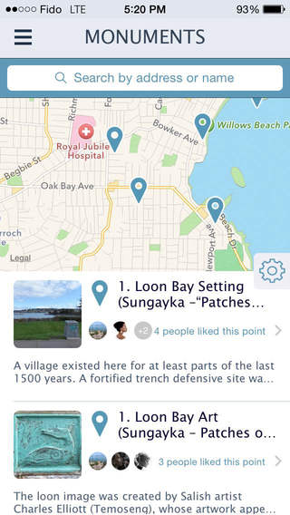
An associated smart phone app is also available. This app provides a self-guided tour of eight First Nations Monuments in the waterfront community of Oak Bay, bordering Victoria, British Columbia, Canada. A map shows a suggested 1.5 hour drive, a 2.5 hour bike ride or a 5 hour walk. The Monuments feature artwork by Salish artist Charles Elliott and stories from Songhees artist Butch Dick about traditional First Nations culture and history and sustainable use of natural resources. Audio clips and text describe scenic coastal picnic stops, cafes, washrooms, parks and other services along the route. Users learn about the long and deep relationship with the land and the sea of the original First Nations inhabitants, ancestors of today’s vibrant Lekwungen communities – the Songhees and Esquimalt Nations.
Users can see a list and map of the monuments (with directions) and then can tap to view additional information and listen to interpretive audio clips.
Site details can be easily saved and shared via Facebook and email.
Download the app for free here. Download the PDF below: